Roman
A survey carried out by Kris Lockyear and his team at Verulamium (St Albans)
Sensing the Iron Age and Roman Past: Geophysics and the Landscape of Hertfordshire is a new blog about an Arts and Humanities Research Council funded project being carried out by Kris Lockyear of University College London. He and interested local groups will be investigating a number of Late Iron Age and Roman sites throughout Hertfordshire — from small farmsteads to the city of Verulamium — across the county that hold the potential to yield new information about this imporant period in the county’s history.
On Wednesday 5 June 2013, I was telephoned by a Mr King, who explained that a deep hole had appeared in his brother’s field in Kelshall, 4.8 km (3 miles) south-west of the centre of Royston. It had appeared during the beet harvest earlier in the year and the harvester had almost fallen into it. As it was close to a public footpath, the brothers were concerned that it might pose a danger to walkers (as well as hindering their ability to farm the field). They were keen to get an opinion on what it might be, so I arranged to visit the site on the morning of 7 June.
On the day of my visit, there was only a low growth of crop in the field, around 25 cm high, but this was enough to make the hole invisible from all angles. It only became visible as a slight depression in the field surface from around ten metres away. This alone made it dangerous, as it would be easy to stumble into it in poor light, especially if one were not paying attention: a running dog would be even more vulnerable.

The hole in the King brothers’ field at Kelshall
The hole proved to be a vertical shaft cut directly into the chalk. It was circular and had a diameter of around a metre. Above the chalk, there was a depth of about 70 cm of topsoil over the top of the chalk, more than double what I would expect in a ploughed field at the highest point in the village. This gives a valuable clue about the nature of the shaft. The bottom of the cut could not be seen in the strong June morning sunlight, so Mr King and I tied a stone to a measuring tape I had brought with me and we lowered it into the hole; it hit something solid at a depth of about 4.3 m, although I learned from the farmer that when it had first appeared, he had measured it as more than seven metres deep.
The edges of the shaft were clearly deliberately cut, with blade marks visible in places. This rules out a natural explanation, such as a sinkhole. At the same time, there were no hints that it had ever been lined, either with bricks or timber. No datable objects were visible in the soil around the top of the hole.

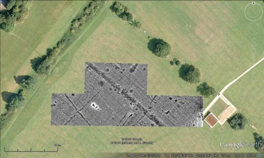
Cropmarks at Kelshall showing the location of an abandoned settlement
There were already clues about what the hole might be. Aerial photographs have revealed cropmarks of linear ditches, including a possible ditched trackway, running through the field, recorded in the Hertfordshire Historic Environment Record as number 6218. The field immediately to the west has also revealed cropmarks, including pits and ditches (Historic Environment Record number 16981). These suggest that this hilltop was formerly the site of human habitation and the presence of a ditched trackway suggests that it might have been occupied during the Roman period (AD 43 to 411).
This makes sense of the feature. During the 1970s and 1980s, a number of Roman wells were investigated at Clothall Common in Baldock, most of which had the same character as this hole: cut directly into the chalk bedrock with no lining, at least, not below the topsoil. Most of them had been left at least partly open when the well stopped being used to obtain water (perhaps when the water turned sour, as can happen), and the top would gradually erode and fall into the shaft. This creates a cone (known as a “weathering cone”) around the top of the well: this is what made the topsoil appear unusually deep in this example, as we were looking at the soil inside the weathering cone, not just the topsoil.
So the King brothers have a Roman settlement on their land. The abandoned well, which had probably never been filled in properly, suddenly appeared in their field when the fills at the top suddenly slumped and fell to the bottom of the shaft. In looking at the aerial photographs, it is possible to see the position of the well in relation to the buried ditches. It appears to have lain close to the track through the settlement, which seems to have been more extensive than a single farmstead. We have a new Roman village to add to the map, thanks to Mr King!